Return to mwra.com home
Massachusetts Water Resources Authority
ADVISORY
DATE:
October 28, 2011
CONTACT:

Ria Convery, Communications Director
(617) 788-1105, <ria.convery@mwra.state.ma.us>

MWRA WEEKEND WEATHER ADVISORY

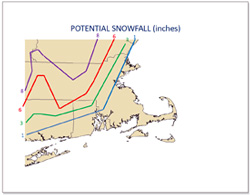
Below is a summary of the weather forecast for the weekend.

This forecast was provided during a National Weather Service conference call this morning. Attached are the Powerpoint slides sent to the conference call participants.

All MWRA facilities will be ready and storm level staffing is being planned at this time.

Please visit the National Weather Service web site for storm updates.

link to national weather service presentation

National Weather Service Update [PDF}


High Impact Storm for the Weekend

HEAVY SNOW

  • Winter Storm Watch for much of interior southern New England
  • Risk of extensive tree and power line damage from heavy wet snow accumulations
  • 4 to 8 inches possible many interior areas with locally higher amounts of 8 to 12 inches in higher terrain
  • Rain or mixed rain and snow in afternoon changes to snow interior by late afternoon or evening

WIND

  • Strong winds along coast
  • High Wind Watch may need to be issued later for coastal zones (gusts 50 to 60 mph possible)
  • Gusts 20 to 25 mph exposed interior high terrain
  • Gale to Storm force winds just off the coast
  • Seas building to around 20 feet Saturday night – perhaps even approaching 25 feet Stellwage Bank and waters east of Cape Cod
  • Strongest winds likely 8 PM to 3 AM

HEAVY RAIN

  • Street/poor drainage flooding likely especially along and southeast of Boston to Providence corridor
  • Small streams may become bankful across RI and southeast MA Saturday night
  • Pawtuxet River may approach minor flood
  • Heaviest rain southeast New England Saturday 4 to 10 PM

COASTAL FLOODING

  • Minor coastal flooding during Saturday afternoon high tide
  • Minor to moderate coastal flooding for early
  • Sunday morning high tide
  • Significant beach erosion possible east and northeast facing shorelines – especially during the early Sunday morning high tide

###

Back to top

Posted October 28, 2011